QUEBEC –
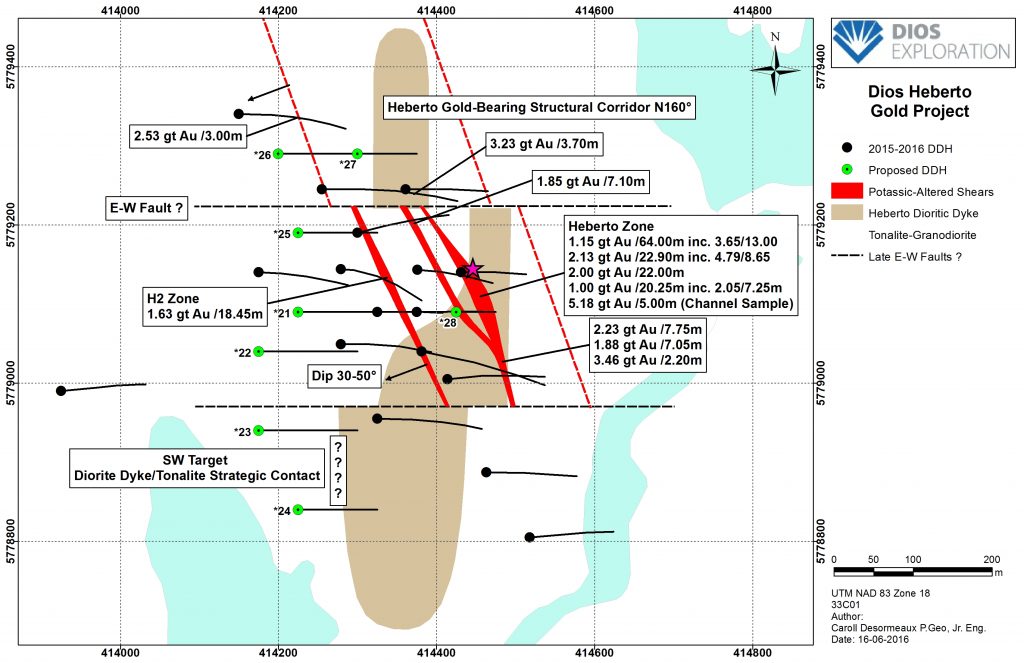
Dios Exploration of Montreal has released a structural gold map of its Heberto zone. The holes were shallow (150 to 200 metres), drilled in outcrops at the Au33 project in the Lower Eastmain River area.
[caption id="attachment_1003714613" align="alignleft" width="300"]
 Structural map of the Heberto gold project of Dios Exploration.
[/caption]
Last year, Dios reported that the first hole it drilled returned 22.90 metres grading 2.13 g/t Au including a higher grade 8.65 metres (true width) at 4.79 g/t. The company said at the time that mineralization consists of quartz carbonate and biotite (magnetite) stringers associated with traces of pyrite and chalcopyrite. This material is hosted in a plurimetric north-south striking shared potassic altered contact zone. Characteristic potassic alteration is made of pervasive and/or fracture filling silica and biotite with more or less microcline, The microcline component is generally better developed in most foliated sections, the company says on its website.
Drilling north and south of the Heberto zone has also intersected similar style gold-bearing zones.
See the June 15, 2016, news release at
www.DiosExplo.com/news.php?id=20160615-00 for the latest positive drill results.

 Structural map of the Heberto gold project of Dios Exploration.[/caption]
Last year, Dios reported that the first hole it drilled returned 22.90 metres grading 2.13 g/t Au including a higher grade 8.65 metres (true width) at 4.79 g/t. The company said at the time that mineralization consists of quartz carbonate and biotite (magnetite) stringers associated with traces of pyrite and chalcopyrite. This material is hosted in a plurimetric north-south striking shared potassic altered contact zone. Characteristic potassic alteration is made of pervasive and/or fracture filling silica and biotite with more or less microcline, The microcline component is generally better developed in most foliated sections, the company says on its website.
Drilling north and south of the Heberto zone has also intersected similar style gold-bearing zones.
See the June 15, 2016, news release at


Comments