[caption id="attachment_1003740129" align="aligncenter" width="550"]
 Sea to Sky Landslide map Credit: Minerva
[/caption]
VANCOUVER –
Minerva Intelligence, a company focused on knowledge engineering, has released an interactive and constantly updated map of B.C.’s Sea to Sky region to the general public. The GAIA Sea to Sky Landslide map uses proprietary artificial intelligence technology developed by Minerva to show landslide susceptibility in the province’s Sea to Sky region.
The map deploys artificial intelligence to assess where a landslide might occur to allow users such as geologists, homeowners and insurance underwriters to take the appropriate steps to manage this type of hazard.
The Sea to Sky Landslide Map, part of the company’s GAIA Natural Hazards artificial intelligence (AI) platform, was a pilot project for Minerva – it amalgamated publicly available databases and combined these with its unique AI technology. It is the company's first Software-as-a-Service (SaaS) product to be used in a commercial capacity.
Minerva's GAIA Natural Hazards AI platform uses proprietary AI technology to provide insights by identifying hazard zones through analyzing public datasets, visualizing multiple hazards simultaneously, assessing current, 24-hour and 48-hour hazard forecasts based on weather conditions, and expressing the attributes and scoring system in plain language.
“By using Minerva's cognitive AI to identify relationships between various geomorphological parameters, we can essentially get an unbiased second opinion to augment our own geohazard assessment,” Nathaniel Tougas, a geohazard consultant in British Columbia, said in a release. “The GAIA Landslide map provides geological engineers with AI tools and insights that have never been available in our field, and this is truly exciting to me.”
“We are thrilled to be debuting a SaaS product in the natural hazard space, furthering our strategy of applying our technology to geohazard consulting and insurance sectors,” added Scott Tillman, CEO of Minerva Intelligence. “The GAIA Natural Hazard AI platform represents a significant opportunity for our technology to help in natural hazard risk analysis and disaster risk reduction initiatives, and this application further validates our belief that there is a real need and demand for what Minerva's software is able to offer. We look forward to expanding the scope of the map to include more locations in the near future.”
The Sea to Sky Landslide Map is available free to the public for a promotional period before moving to a subscription model. To access the maps, visit
www.MinervaGeohazards.com.
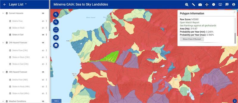
 Sea to Sky Landslide map Credit: Minerva[/caption]
VANCOUVER – Minerva Intelligence, a company focused on knowledge engineering, has released an interactive and constantly updated map of B.C.’s Sea to Sky region to the general public. The GAIA Sea to Sky Landslide map uses proprietary artificial intelligence technology developed by Minerva to show landslide susceptibility in the province’s Sea to Sky region.
The map deploys artificial intelligence to assess where a landslide might occur to allow users such as geologists, homeowners and insurance underwriters to take the appropriate steps to manage this type of hazard.
The Sea to Sky Landslide Map, part of the company’s GAIA Natural Hazards artificial intelligence (AI) platform, was a pilot project for Minerva – it amalgamated publicly available databases and combined these with its unique AI technology. It is the company's first Software-as-a-Service (SaaS) product to be used in a commercial capacity.
Minerva's GAIA Natural Hazards AI platform uses proprietary AI technology to provide insights by identifying hazard zones through analyzing public datasets, visualizing multiple hazards simultaneously, assessing current, 24-hour and 48-hour hazard forecasts based on weather conditions, and expressing the attributes and scoring system in plain language.
“By using Minerva's cognitive AI to identify relationships between various geomorphological parameters, we can essentially get an unbiased second opinion to augment our own geohazard assessment,” Nathaniel Tougas, a geohazard consultant in British Columbia, said in a release. “The GAIA Landslide map provides geological engineers with AI tools and insights that have never been available in our field, and this is truly exciting to me.”
“We are thrilled to be debuting a SaaS product in the natural hazard space, furthering our strategy of applying our technology to geohazard consulting and insurance sectors,” added Scott Tillman, CEO of Minerva Intelligence. “The GAIA Natural Hazard AI platform represents a significant opportunity for our technology to help in natural hazard risk analysis and disaster risk reduction initiatives, and this application further validates our belief that there is a real need and demand for what Minerva's software is able to offer. We look forward to expanding the scope of the map to include more locations in the near future.”
The Sea to Sky Landslide Map is available free to the public for a promotional period before moving to a subscription model. To access the maps, visit

Comments