Changing the face of mining from above
The market for UAVs (unmanned aerial vehicles) in the mining industry is now firmly established as many operators and exploration services of all sizes have already acquired equipment, or had work done, through service providers in recent years.
And, because safety and cost savings are major considerations for all miners, drones, and the technological opportunities they bring, are a perfect fit on all accounts.
At least that’s according to hardware distributor UKKO of Palmerston, Ont., a Division of Ag Business & Crop., that says early adopters of the drone technology will benefit since it’s here to stay and will grow at an accelerated pace for at least another decade.
And here’s a look at why.
Access to the technology is now widespread, but not all equipment is created equally, or for the same application. Because of this, drones come in all forms; from fixed wings or rotary, from under 2kg to well above that in order to produce various types of data.
Topographic, multi-spectral, or thermal are just some of the sensors that are utilized in the mining market to help make the devices such valuable tools.
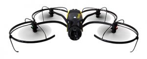
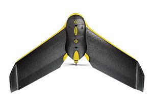
For example, the senseFly series of UAVs are designed for mapping, surveying and inspection work. For mapping work, the eBee fixed wing, is designed to gather high resolution, down-looking pictures of any operation and quickly generate 3D models of high-density point clouds, and the Albris multi-rotor drone is designed to gather ultra-high resolution imagery, in colour or thermal, of infrastructure in hard to reach areas.
Applications cover most site operations and UAVs can be shared between departments. The benefits of collecting data immediately when you need it makes it even more valuable to the operator. Whether looking for volumetrics on a quarterly/monthly schedule, geotechnical surveys, hydrology and hydrogeology investigation, the use of the UAV platform will only grow with time and quickly be utilized on a regular basis.
Simplicity and safety of operation is at the heart of all drones and for those reasons, training time is relatively short, but still necessary and strongly suggested by Transport Canada.
All flights should always be orchestrated from a safe location and away from potential hazards. Drones eliminate the need for mine personnel to go down an open-pit slopes in treacherous conditions or, sending an environmental specialist in the vicinity of tailings to collect thermal imagery.
In all cases, the UAV becomes the remote eyes of any employee, and in the process gathers tenfold the amount of data that can be an
alyzed in the comfort of an office away from all the commotion.
Another very important feature to all systems is that they integrate the collection workflow to provide a combined data collection system. In the case of the eBee (fixed wing) mentioned earlier, it can collect in high-and-wide macro environments whereas the Albris (quad copter) is better suited for looking into details in micro environments.
A Pix4D Mapper Pro can be used to integrate all imagery to generate a final combined project dataset.
Just as GPS altered surveying methodology, the use of UAVs is rapidly changing the face of the mining industry by encouraging operation efficiencies, time savings and providing a return via reliable and precise data. The simplicity and ease of use of UAVs has given, and continues to give, early innovators many benefits, and a competitive edge, in a rapidly changing market.
Albris – The Intelligent Mapping and Inspection Drone

With the senseFly Albris, operators can switch between capturing high-resolution still, thermal and video imagery during the same flight, without landing to change cameras. Thanks to the drone’s unobstructed field of view and its head’s 180º vertical range of motion, clear, stabilized imagery can be captured. The senseFly Albris features five ultrasonic and visual sensors installed around the unit for live situational feedback to the pilot operating in tight spaces. These provide the situational awareness required to operate the Albris close to structures and surfaces, even in confined and less-than-desirable environments, in order to achieve sub-millimeter image resolutions (without the movement issues caused by zooming in from afar).
All moving parts are protected with lightweight shrouding and high-powered LED lights and a flash to collect data in environments.
The Albris offers full flight mode flexibility; including, Autonomous, GPS guided mapping mission, or a livestreaming Interactive ScreenFly flight. It can also start in mapping mode and ‘go live’ on demand without the use of the GPS system in deprived environments such as tunnels, under structures, and canyons.
eBee – The Professional Mapping Drone

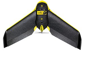
According to UKKO, the eBee is presently the only fixed wing UAV compliant with Transport Canada. Flown at lower altitudes, the eBee can acquire images with a ground-sampling distance (GSD) of down to 1.5cm per pixel. It also flies, captures images and lands itself. However, flight plan can be altered anytime. Thanks to its ultra-light construction, the eBee weighs just 800g and features a safety conscious rear-facing propeller and autopilot to help manage a wide range of intelligent failsafe behaviours.
eBee RTK – The Survey-Grade Mapping Drone
Built on the same platform as the normal eBee, operators can produce absolute dense point cloud, orthomosaic, and digital surface model accuracy of down to 3cm without the need for GCPs – meaning less time in the field and high precision in even the most inaccessible areas. The drone’s supplied eMotion ground control software connects to the base station and broadcasts correction data to the rover (the eBee RTK) – no additional logger or third-party software required. The eBee RTK is compatible with most leading brands of base station and virtual reference station (VRS) networks, working alongside most existing portfolio of instruments. This technology can be used in large area mapping such as open-pit mines or corridor mapping. It can also cover very long distancesBuilt on the same platform as the normal eBee, operators can produce absolute dense point cloud, orthomosaic, and digital surface model accuracy of down to 3cm without the need for GCPs – meaning less time in the field and high precision in even the most inaccessible areas. The drone’s supplied eMotion ground control software connects to the base station and broadcasts correction data to the rover (the eBee RTK) – no additional logger or third-party software required. The eBee RTK is compatible with most leading brands of base station and virtual reference station (VRS) networks, working alongside most existing portfolio of instruments. This technology can be used in large area mapping such as open-pit mines or corridor mapping. It can also cover very long distances .
Comments