Mining with the end in mind
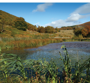
Cwmtillery Reservoir near Abertilley, South Wales, U.K., is located on reclaimed industrial land. Credit: Christopher Jones/istockphoto.com
The Landform Design Institute (LDI) helps the mining industry, regulators, Indigenous and local communities, and academia work together to move beyond the status quo, mainly by fostering a global community of reclamation practitioners and providing landform design “how-to” publications and training.
At the institute’s inaugural landform design workshop held shortly after its founding in October 2019, we asked the seasoned reclamation participants, “What do you worry about? What keeps you up at night?” The group responded, “We spend millions of dollars and create beautiful reclamation, but we’re stuck without signoff or our bond money back, and the users can’t get back on the land.”
The LDI’s subsequent gap analysis provided some of the insights as to why: a lack of a shared vision and goals, little financial incentive for progressive reclamation, and concerns about residual risk. And despite a rich body of literature in what ought to be done, there is little practical, how-to, boots-on-the-ground guidance. Instead, each mine develops its own local know-how and practices.
Landform design elevates existing practices to achieve successful reclamation. It is the integrated, multidisciplinary design and construction of mining landforms and landscapes, directed by a dedicated team working with different mine operations groups and others over the life of the mine and beyond. The team’s focus is on reclamation that will steadily fulfill the specific vision, goals, and objectives of the mining company, the regulator, and Indigenous and local communities.
Collaboration: planning, integration, governance
At its most basic level, mining with the end in mind means recognizing, and constantly reinforcing, the intended end result for the land. For example, while the need to transform waste rock and tailings facilities into something resembling natural landforms is widely acknowledged, sustainable mining involves incorporating and implementing these measures into mine operations even before breaking ground (or adjusting the approach if mining is already underway). This will improve long-term landscape performance and lower costs, reduce liability and risk, and help mines meet their commitments.
Collaboration is key. In creating a shared vision and stewardship for the reclaimed land, the mine, Indigenous peoples, and local communities must work together to earn one another’s trust. Indeed, the industry is embracing the emerging concept of co-reclamation, or building the reclaimed landscape with –
rather than for – the land’s users. The industry should actively acknowledge its responsibility to support their duty of stewardship. In this way, long-term aftercare of the reclaimed land can be welcomed and well-funded.
Much comes down to the integration of planning, design, and construction of mining landforms and landscapes – across spatial and time scales, disciplines and communities, and the multitude of mining activities and teams. Using such an approach, industry can deliver financial returns to shareholders and society while creating safe, useful, and productive reclaimed land.
Central to this integration is recognizing that effective governance (and corporate responsibility for the work) is a significant component of landform design. Often, mines use a management steering committee to oversee the process with a responsible manager or vice-president. Including members of Indigenous and local communities in governance oversight will strengthen the likelihood of an outcome satisfactory to all.
Reclamation strategies: where to begin
The Institute is proposing a new approach. For each mine, sustainable and responsible reclamation starts with the formation of a landform design team. This group of specialists works together over the life of the mine and beyond in development, operations and progressive reclamation, final reclamation, and aftercare. The team typically includes representatives of six to 12 disciplines. A lead designer takes overall responsibility for the design and construction.
This is a significant change from the commonly used current practice, one that separates the reclamation team from the mining design, construction and operations teams. Often the landform is handed over to “start closure and reclamation” only after or well into mining, which is far too late.
The team, with oversight from the established governance model, sets out clear land-use targets, goals, design objectives, and design criteria for the landform design in a Design Basis Memorandum. This document anticipates that the land will evolve over time, physically, chemically, ecologically, and socially. The team aims to design and maintain the land to adapt to these changes, including those driven by an ever-changing climate.
The design effort is worked at all spatial scales – regional, landscape, landform, element – simultaneously. These scales include a mining region (a collection of mines), a landscape (a single mine site), the landform (such as an individual waste rock or tailings storage facility) and the landform element (a designed feature on the landform such as a berm, outlet, or access route).
Most design is undertaken at the landform scale. Temporal scales are also an important consideration for a design in which evolution by natural processes is ongoing.
Fundamentally, landform design depends on construction and operations teams making it a reality. Landforms and landscapes should be easy to build and reclaim using available technology appropriate for the purpose. Special emphasis should be given to producing initial designs that are realistic, practical, and well costed.
Integral issues for many closure designs include controlling the source of contaminants and avoidance of producing soft tailings. As part of this landform design process, a risk-based approach should be used, and designs created for the most reliable or most likely case. The observational method and true adaptive management are integral components, with predetermined contingencies enacted as needed to allow the evolving land to perform as intended.
An effective design involves several vital components. First is to follow every drop of water through the landscape, as water is both a key to life and a great agent of disruption. Practitioners also need to be familiar with their materials, ready to cover and revegetate all mine waste, and ensure the adequate borrow and conservation of soils. Designs should include the reclamation of every square metre of the project area; any areas left behind are rarely revisited once the trees are grown.
To close the gap and ensure timely access to reclaimed land, progressive reclamation and sign-off should be pursued collaboratively. The landform design and construction team can learn by doing (and the knowledge gained should be well documented). The vision is that progressive reclamation is part of normal operations, land is freed up to be reclaimed every year, and areas available for reclamation are reclaimed within two years.
At any reclamation project, team members can incorporate their experiences into future plans. When a mine closes and its mill shuts down, the amount of land yet to be reclaimed should be minimal. As a mining community, the industry has a duty to share its experiences locally and globally, all the while expanding its closure knowledge by learning from failure and celebrating success.
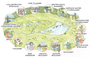
An illustration from the Landform Design Insitute’s 2021 position paper shows a collaborative process is needed to implement landform design. Credit: Landform Design Institute
Gunnar remediation project
While our vision of responsible landform design has yet to adopted widely, a few mines have made important steps toward that goal. For example, remediation efforts at the Gunnar uranium mine and mill, which has a footprint of more than 70 hectares of the Athabasca region of northern Saskatchewan, is based on a shared vision that sprang from extensive community consultations. General design criteria for the 5 million tonnes of unconfined tailing at the Gunnar site were developed to meet site-specific, risk-based objectives. Remedial objectives for the tailings were driven by human and ecological health risks posed by exposure to gamma radiation.
Mitigation measures were chosen based on materials available on site, construction plans that considered seasonal climate variations, robust technical specifications, and a comprehensive quality assurance and control program. A monitoring program was developed to demonstrate performance and track progress. The resulting Gunnar Site Remediation Project minimizes the need for care and maintenance activities or long-term institutional control.
These kinds of strategies form the essence of the 12 guiding principles the LDI considers front and centre in effective landform design. Our aim is to develop these overarching principles into detailed how-to guidance, and to advance the field of mine closure toward a new status quo. The institute is already producing guidance and training and is seeking out corporate and individual members to embrace this vision. Join us at www.landformdesign.com.
June Pollard is a member of the board of LDI and a professional geologist. Gord McKenna is the founder and chair of the LDI and principal of McKenna Geotechnical Inc.

Comments