A transformative technology catches up in the far north
So, how do you measure up three million tonnes of crushed rock and gravel? Just a few years ago, it would have been with at least two surveyors and their cumbersome gear trudging for days around the stockpiles. But in 2016, it’s with an Unmanned Aerial Vehicle – a UAV – multi rotored helicopter or perhaps a foam wing, coupled with a miniature high-resolution camera, a laptop and an operator with the combined skills of an unerring pilot and a genius computer programmer. And, you get it done in a couple of hours.
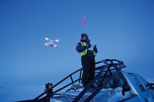
Rob Coolin
That’s what Diavik Diamond Mines has employed as it advances its four-year, $350 million (US) project to build a rockfill dike around its A21 diamond-bearing kimberlite pipe. Gord Stephenson is Diavik’s engineering superintendent on the A21 dike, and estimates it will indeed take three million tonnes of crushed aggregate to build the 2.2 kilometre-long dam to depths of up to 20 meters in Lac de Gras.
“That’s a pretty gargantuan task to survey on foot,” he says, and it’s why Diavik invested in three drones and the required training for Stephenson’s team to operate the system. The survey team now makes a regular bi-weekly flight over the site, then from the extremely high quality images taken by the on-board camera, plots areas and volumes of the aggregate as it is delivered and consumed. He figures that compared to physical surveying, it’s saving the project two workers and $250,000 a year.
UAV technology is hardly news to anyone in the civil engineering world. It’s been in play for a decade or so, but recent innovations in all kinds of technology – from software programming to miniaturizing the drones (called platforms) to enhanced digital imaging – are driving down the cost (from hundreds of thousands, to tens of thousands of dollars) and making it relatively easy to learn.
The mining world is one of UAV’s frontiers. It is steadily transforming the speed, accuracy, safety and scope of how exploration and mine development and operation is evolving.
“Mines are a great application as they’re typically remote and have a controlled airspace. So the safety risks are addressed,” says the Yellowknife-born Stephenson. “We can fly into the sublevel retreat of the mine, where we can’t get people to photograph or see, and produce 3-D imagery of the bottom of the open pits.” “Moving forward, in terms of exploration, I think eventually they’ll be able to get beyond the (current) line of sight operating restrictions safely. Then the field will open up significantly,” he forecasts.
Rules and Regs
Governments around the world are grappling with writing rules for how drones can be used, as the technology is now simple and cheap enough to put it in the hands of the average consumer.
Inevitably, that also means curious or just plain stupid users are spying on neighbours, crashing into property, and endangering commecial air traffic and even birds.
This might not be much of a problem for an exploration program out on the tundra or over a remote forest, but the rules set by Transport Canada apply everywhere in the country, says Colin Charlton, project engineer at Ollerhead and Associates, surveyors and engineers, of Yellowknife.
“Every part of Canada is, to some degree, a controlled air space… even remote country in the Arctic. And to legally fly, you have to be certified, and may even have to apply for specific permission each time you fly your UAV,” he says.
Charlton’s on side with the need for regulations, but he’s frustrated that it’s getting more complex.
“Transport Canada is continuously tightening up its regulations to deter a growing number of unregistered – and inexperienced – drone operators from buzzing around areas they shouldn’t be,” he says. Companies like Ollerhead invest hundreds of hours annually just to maintain compliance for their Special Flight Operating Certificate (SFOC), something he says clients should be demanding as they would shoulder liability if something goes wrong.
Since buying its first UAV platform in 2013, Ollerhead has steadily grown its client sales from 10 flights a year to 50. A good portion of those are exploration juniors and big miners (Ollerhead first introduced UAVs to Diavik) who are getting far more from the images than area and volume measurements, he says.
“A picture’s worth a thousand words. And not only do we have the picture, we have the 3-D data train. They’re looking for the pictures as an inventory they can use years down the road,” says Charlton, noting that one detailed orthophotograph reveals a host of data – from contour and area to vegetation to drainage to contamination – easily saving the client from sending in multiple teams to do specific surveys.
Isn’t this going to cost surveyors like Ollerhead a lot of business? “Not at all, I think it’s actually added to our business. Being a small Northern company, we have to be diverse and UAV’s are in the toolkit.” Charlton is bullish on the prospects for UAVs to play a pivotal role in exploration, especially as more powerful and affordable drone platforms can handle heavier sensors like LIDAR and electromagnetic instruments.
“The biggest issue with drones is their capacity to lift,” says Gary Vivian, President of Aurora Geosciences, a veteran Yellowknife- based mining consulting company. “Sensors for airborne surveys are not light and need some fine tuning to make them smaller.” He’s already purchased a UAV, and is looking at adding an airborne magnetic sensor, an investment worth $100,000.
It’s a bit different in the Arctic
One enterprising UAV start-up that’s getting a lot of attention is Arctic UAV, launched earlier this year at the Nunavut Mining Symposium by multi-faceted Inuk entrepreneur Kirt Ejesiak.

Kirt Ejesiak
It sparked when the Iqaluit-born Ejesiak thought offering drone aerials would enhance his Property Guys real estate franchise. Then one day a neighbor asked him to use his quad copter to check out damage on her roof, and the light switched on that it could have potential beyond selling homes.
“We don’t really see ourselves as a drone company – we see ourselves as an imaging company – doing much more [than just aerial photography] as things advance,” says Ejesiak, whose vision is to operate from Greenland to Alaska. It’s very early days for Arctic UAV, and Ejesiak has yet to sign up a mining or exploration client.
“Our pitch is to say, instead of flying people up from the south, why don’t you hire some locally-trained operators?” Arctic UAV also offers to train pilots for companies that want to build their own system. “It’s a bit different here in the Arctic – not like flying over a football field.” Arctic UAV has Transport Canada certification to operate across the huge territory, including over communities and mine sites. It has invested in training eight certified pilots (two are based at its Ottawa office), and five different drone platforms in its fleet. The largest is the Dutch HEF30, a gasoline-powered helicopter drone capable of long-distance surveys with bigger payloads for high-end sensors.
Current Transport Canada regulations require the operator to be in constant visual range of the drone – limiting its range to less than a kilometer – but Ejesiak, like Diavik’s Stephenson, is hopeful that will change, especially considering the Arctic’s vast distances over land and sea.
Are UAV’s a transformative thing?
“It’s certainly promising,” he says, cautioning that tche Arctic is a stern testing ground and any new technology needs thorough troubleshooting and modification to make it fit. “It might look good on paper, but we know the pitfalls… I think we’re almost there.” An article in the High North News, a web newspaper published by the Nord University in Norway, picks up Ejesiak’s hope that one day, regulations will allow UAVs a longer leash and broader scope to flex their potential.
“If countries are willing to have honest and open discussions, as well as fund companies who are looking into improving UAV technology specifically geared to northern climates, there is huge potential for what can be accomplished,” says the paper, citing Arctic search and rescue, security and wildlife monitoring as likely advantages.
“It is not hard to see why so many people are enthused by the idea of using these devices in the Arctic, but there are important conversations and research that needs to be done before this potential can truly be unlocked.”
Comments